GEOMEDICINE AND HEALTH 4.0: NEW FRONTIERS WITH GEOSPATIAL TECHNOLOGIES
September 22, 2021 2023-05-26 15:29GEOMEDICINE AND HEALTH 4.0: NEW FRONTIERS WITH GEOSPATIAL TECHNOLOGIES
GEOMEDICINE AND HEALTH 4.0: NEW FRONTIERS WITH GEOSPATIAL TECHNOLOGIES
As a geospatial and systems modelling expert and thought leader, Nashon Adero was invited as a panellist and presenter at the 11th IREN East Africa Thought Leaders Forum on Megatrends: eHealth and Telemedicine in East Africa
Nairobi, September 22, 2021
Below is a summary of the key message of his presentation.
Geography and health
Good health and well-being (SDG 3) is foundational to socio-economic transformation. Geomedicine explores the interface between health and geography. Spatial metrics, obtained through geospatial technologies, are a critical component of decision support systems since effective policy action needs to be calibrated using location-based intelligence. Public health decisions are no exception; where one lives determines the water one drinks and the air one breathes, hence overall health outcomes. This, in essence, is geomedicine in action. The discovery of the cause of cholera by Dr John Snow in London in the 19th century and the breaking of new ground in the discipline of biogeography by Alexander von Humboldt are exemplary of the central place of geography in lives and livelihoods.
Health 4.0
With the growing wave of data-driven digital revolution manifesting itself in the Fourth Industrial Revolution, also referred to as Industry 4.0, there emerge new frontiers in health governance, hence Health 4.0. The new reality accelerated by the COVID-19 pandemic fosters new megatrends in health service delivery. Telemedicine and e-health, in general, is quickly advancing from the periphery to the centre of attention in modern clinical practice. This welcome development is likely to enhance health service delivery through democratised platform services.
Dynamic model for health sector planning
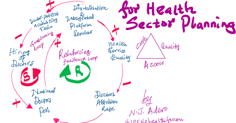
Modelling of health service delivery as a complex dynamic system reveals that increasing the doctor-patient availability is a high-leverage point, which should benefit substantially from digital platform service delivery megatrends. As shown in the loop diagram below, the hiring of doctors exists within a goal-seeking loop – leading to a specific optimal level because the hiring rate is limited by other resource constraints. There is, fortunately, a reinforcing loop that is likely to keep improving the quality of health service delivery through the pathway of enhanced and integrated digital platform services and reduced doctor attrition rates.

Way forward in eHealth
In Kenya, the adoption rate of telemedicine went up with the advent of the COVID-19 global pandemic, SasaDoctor being a commonplace digital platform connecting doctors to patients. Spatial intelligence is key to improving the efficiency and effectiveness of delivering the solutions expected from these upcoming innovations. Delivery by specific registered locations requires the effective application of geospatial technologies, so as to achieve the high level of spatial accuracy, public trust, transparency, and timeliness that modern disease and disaster governance demands in the following areas: testing, tracing, training, and transdisciplinary research.
This presentation shed light on the areas where geospatial technologies are opening new frontiers for the health sector, namely:
- Delivery of medicine and other health-related supplies using satellite navigation and positioning technologies;
- Potential in unmanned aerial vehicles (UAVs);
- Mapping for equitable policy decisions;
- Improving clinical diagnostics using FAIR (findable, accessible, interoperable, resusable) standards and integrated health informatics anchored on databases with GIS-mapped environmental variables;
- Application of AI, ML, robotics and telemonitoring for measuring and evaluating health outcomes;
- Social inclusion in awareness raising using mapped and shared visual evidence;
- Predictive public health management based on spatio-temporal models.

Nashon, a geospatial expert, lecturer and trained policy analyst applies dynamic models to complex adaptive systems. He is a youth mentor on career development and the founder of Impact Borderless Digital.
Related Posts